Wednesday, September 27, 2017

Fourth St. at Spring/Washington Sts.

Standing at the corner of Fourth and Washington is the Wesley Building.  This is a multi-family apartment done in the Prairie School style.  Note the use of stained glass, wood, stucco, and the details such as  at the entry.  This structure is in poor condition.  How can you tell?
Across the street is Washington Park.  This land was at one time (until 1906) the railroad yards for the Omaha Railroad.  When the tracks moved closer to the river, the city made it a park. Washington park was once the site of the Omaha Railroad's rail yard. The city of Mankato has 32 parks, another of those parks is Sibley Park.

In the late 1950�s, Gus Johnson Plaza and the Downtowner Apartments (one block away) were the local hospitals.  Later, they merged.

Walk South on Fourth Street.

At the Corner of Main Street and Fourth is Grace Lutheran Church.  Look at the mosaic at the end of the Sanctuary.  Note this is made up of very tiny tile pieced together.  Acknowledgements are in the lower right corner.  The firm that made this is in Venice, Italy, and has been since the 14th Century.


Continue along Fourth Street to the Court House.  Look up.  Observe closely.  Is
there a symbolism connected to the building? 
Just a few more blocks, and you will be where you began.  Thanks for taking the tour and learning about the City of Mankato!


North Riverfront Drive and Spring St.

On the corner of Spring and North Second Streets is Immanuel Lutheran Church.  This structure was burned to the ground in the 1971 when it was struck by  Lightening, and all but the walls were destroyed.  The building was redone in a very modern but traditional way.  Do you like the spires on the top, or do they seem awkward to you? 
One of the largest tragedies as a result of fire was the loss of some of the finest German stained glass windows in Southern Minnesota.  The windows are an uncommon technique described below.
From Spring Street, cross North Second, then go to Fourth St. and turn right.


Old Town (Riverfront to Plum Sts.)

This area has some of the best �turn of the century� commercial and industrial architecture left in Mankato.  Because this area was not destroyed during Urban Renewal, today we can see what Mankato used to look like.
324 Riverfront Drive, Hubbard Mills (now Cargill Mills) is the key ingredient to this neighborhood.   At one time powered by steam (now electricity), the machinery inside is essentially the same as when it was installed in 1908. 
The large silos are state of the art, slip form, concrete, storage structures built in 1996.  This building shows the strong influence of agri-business on the Mankato area.  Imagine what these would look like illuminated coming into Mankato on Highway 169 at night. 
At the base of the silos, notice the Blue Cross and Blue Shield Medical Insurance Building.  This was once the American State Bank.  Note how the materials (brick and limestone) coupled with form, arches, cornices have been incorporated into these two structures to help to blend in with the rest of Old Town.
As you walk along Riverfront, look at the forms of the buildings--  the ornate columns and piers, the cast  iron that was made locally. 
Look at 411 North Riverfront Drive.  The cornices are stamped sheet metal.  They are made through mass production techniques, and they are simply assembled on a wooden armature and suspended from the building. 
Thinking about the �stability� these buildings portray, what do you think it says about those who built them? 
Turn the corner at Spring Street to:

Downtown to Old Town

Now, look at the Embers.  It is a classic example of the �road rash� that can happen when planners and decision makers do not establish design standards for a community.
Look to your right.  Notice here the impact of the bluffs as landmarks that define the community and how they essentially serve as a �frame� for the city.  Notice the trees, imagine what they must look like during the fall.  Or do you remember?
Look at how St. Peter and Paul Church announces itself to all who enter the city as it towers majestically above.
Can you find the armory building?  What is the message that you receive?
Now find the Blue Earth County Court House.  What does that say to you?


Downtown to North Mankato.

How do you feel under the bridge?  What does it  inspire in you?  Does it make you want to walk more, or is it intimidating to pedestrians? 
Look at the changes in the Bridge over time.  The first photo is the original crossing.  The second photo is the bridge built in 1880 which had a pivoting section to allow barges to come through.  The last photo is how the bridge span looks today.  Is there an style you like more than the others?  Why?


Riverfront Drive � Memorial Park

It is linked to December 26, 1862.  On this cold day, Mankato became an infamous part of the constant struggles between the Native American population and the United States government.  Thirty-eight Dakota were hung at the site of the Buffalo.  It was the  largest mass execution ever recorded in U.S. history.
What do you think this meant for the Dakota people?  Do you know for years afterward they were afraid to drive through Mankato except at night?
Today, Mankato hosts a large traditional Wacipi Pow Wow, (meaning �to dance�) one weekend annually.  It is an attempt to bring all nations back together again.  
What significance does this park have for Mankato?  For Minnesota?  For the Nation?
Is this a place where you feel safe? 
Look at the bridge that connects Mankato to North Mankato.

In honor of Amos Owen, Norman
Crooks, and Hereditary Chief Ernest
Wabasha for their lasting efforts toward 
reconciliation among all peoples.
Grandfather, I come to you this day in
my humble way to offer my prayers for
the thirty-eight Dakota who perished in
Mankato in the year of 1862.
To the West, I pray to the Horse
Nation, and to the North, I pray to the
Elk People.
To the East, I pray to the Buffalo
Nation, and to the South, the Spirit
People. 
To the Heavens, I pray to the Great
Spirit and to the Spotted Eagle.  
And Below, I pray to Mother Earth to
help us in this time of reconciliation. 

Grandfather, I offer these prayers in my
humble way.
To all my relations.
-Amos Owen,
Prayer in �Water in the Rain

Main and Riverfront Dr. � Old Towne

Walk into the Library lobby.  Do you notice the lack of walls?  In the middle of the lobby entrance is a waterfall over rocks.  These rocks, �glacial erratics� were carried by the ice ages and deposited here.  They are now used for �white noise�, to overcome any background coughing, sneezing, or laughing that would normally make walls necessary.  Imagine what a sky light over the water fountain would have done! 
Notice the Maud Heart Love Lace reading room to your left.  Do you know who she is?  She wrote a series of children�s books (known as the Betsy-Tacy Stories) about growing up in the Lincoln Park neighborhood. 
Walk out through the north doors, and see an example of planners attempting to show cities that they care about pedestrians.  But do they?
This landscape design project cost somewhere between $75,000 � $100,000 to insert the concrete and vegetation. Is it worth it?  Do you see people out frolicking in the garden?  Or are you the only ones there?  Would you want to be here to read or study?  Think about the bridge� the highway� the noise� the lack of privacy�  Now, again would you want to read or study here?


Exit the library on the opposite side and look to the right.  Across Riverfront Drive, you will seeMemorial Park?
What do you think it is?
Who do you think it is for? 

Walnut St.

At one time the survival and growth of a town relied on the service that railroads provided.

Look through the parking ramp and  see the old Mankato Railroad Station, which has been adaptively reused to house several businesses, including the Mankato Area Chamber and Visitor�s Bureau.  It could have easily been torn down, but was saved.  It  serves as a valuable landmark to our past, while helping Mankato define its future.

On the left, just beyond the parking ramp, is 115 South Front Street, the four story Martin Building.  Behind you on the right at 105 Walnut Street is the nine-story Walnut Towers Apartments.  Both buildings are about the same size but note how modern materials and technology (heating, ventilation, and air conditioning) have influenced the amount of space required between floors to more than double the space available in the Walnut Tower.
Now you see the Holiday Inn front of you.  Note the almost �blank stare� the building has.  The lack of windows and a strong entry deny a strong statement to guests.  Originally this was designed as a nine story tower sitting in alignment with �Old Towne�. Unfortunately, this was changed, and it was �turned on its side� to become the way it looks today.
Go into the lobby which is considered a public passage to Front Street.  Note the lack of locks on the doors.  Also how hard it is to walk around this building because of sidewalks.

As you enter, look at the ceilings.  Why are they so low?  Now, proceed and they explode above you in greater space.
Exit and carefully cross Main St. to the LIBRARY.

Hickory St.

Turn around. 
Note the sense of entry the new City Hall structure provides and the sense of presence it brings to the community.  Note some of the landscaping effects that add nature to the setting and soften the mass of brick and stone.

Look to your right at two of the only remaining historic buildings along what was once Front street.  Graif�s Clothing is located in a building that was once both a bank and a prestigious office building.   Look at the design details on the outside of the building.  Go inside, look at what was once the bank lobby, the  columns and the coffered ceilings.
Ahead and across Hickory Street is the Ellerbe Building.  This was once the First National Bank building until they relocated.  This is an example of Prairie School architecture at the early turn of the century.  It reflects Louis Sullivan in many details of its design.  It was actually designed by Ellerbe and Round Brothers Architecture Firm in the Twin Cities, but the influence of Sullivan is undeniable.  Compare this with some of his work in nearby Winona and Owatonna, if you have the chance.
Fortunately, this building was placed on the National Register of Historic Places in the 1980�s, and therefore was spared from the demolition and reconstruction around it.  In 1994, it was incorporated into the Midwest Wireless Civic Center (formerly the Mankato Civic Center).
The Civic Center is a fine example of modern design incorporated into what was the downtown. This facility can change from a basketball, hockey, to a stage floor in a matter of hours.   It is expected to make its first $400 profit in 2000.
Walk through the Front Street lobby of the Civic Center, then straight ahead into the outside mall extension leading to the Holiday Inn. In another era Mankato was host to the Saulpaugh Hotel.


Cherry and Front Sts.

Stay right and walk across the S. Front Mall Plaza.
On the one side is Mankato Place shown by the �ENTRY� by the door.  Once this was Front Street--the main commercial street of Mankato.  Until about 1975, this was a working street lined with big stores and small shops, apartments and offices above them.  Under the Urban Renewal Program, what was once the downtown was demolished to make way for �new� mega-block development.
Nearly five blocks of the community's commercial core  along Front St. was flattened.  Most of the businesses closed or relocated to the shopping centers on the �Hilltop� or to other towns far removed from Mankato.  
However, the new development never came.  Today, the only block of commercial space essentially somewhat intact is the block of stores inside the Mall.   The mall was built in response to the major shopping centers that lured Sears and others from the downtown.  The major retail anchors that remained in the mall were Penney�s and Brett�s.  The mall itself did quite well in-spite of the competition for nearly fifteen years.  Later with the development of River Hills Mall, Penney�s relocated there.  Brett�s department store, the only other retail anchor, closed its doors forever in 1992.
Since that time much of the mall has stood vacant with the primary business occupants being BW3 and the Y Barbershop.  In an effort to reuse the mall space, more of the structure was removed and a new City Hall and other government offices were located there.  This gave the mall a sense of place again within the community.
The remainder of the mall is a good example of a unique re-design that lends itself to many kinds of current and future uses.  Note the orientation of the corridor system which is sinuous rather than perfectly linear, the sky lights which permit natural light to penetrate into the interior, little nooks and crannies that serve as conversation and social gathering spots, the central atrium which  is well adapted for many kinds of performances, presentations and displays, the multiple levels with access by both elevator and escalator and the presence of theaters, bars and restaurants which generate activity both during normal business hours and throughout the evening as well.
Exit out the North end of the mall through the Intergovernmental Center to Hickory St.


Cherry and Second Sts.

Walking towards Cherry Street:
Ahead of you on the right is the Mankato Post Office and Federal Office building.  What is it constructed of?  What does it say about the natural resources of this area?  An addition was made some time in the twenties.  Can you tell which is the original and which is the addition. (Ignore the loading docks on the back).


 On the corner is the Multi-Church Center.  How does this fit into the context of the street?  How do you know it�s a church?  Yes there is a spire on top of the roof.  Could the roof be painted with red stripes and an image of the Colonel be put on top(as a weather vane) and then turn the whole thing into a KFC?  Have you ever known of another facility that served multiple congregations?  (St. Peter Lutheran-Catholic Church?)
Behind you on the left is the Chatham Square Apartments, once the Inn Towne Apartments. This structure was originally a motel built in the 1950�s.  It was unsuccessful because the rooms were too small relative to modern hotel designs.  In the 1980�s it was converted into apartments rather than being torn down.  Another good example of adaptive reuse.


On the opposite other corners across the street are the Earl Johnson Furniture stores.  The red brick building with the limestone accents and green awnings was once a tractor repair and machinery sales operation.  The long low one-story building was once the Greyhound Bus Depot for Mankato. 
Now turn left onto Cherry and notice the bus stop across from Bagel Brothers.  You have now entered what was once the �Downtown Commercial Core".


Warren and Second Sts.

Look at the Florist Shop.  It is obviously an addition to the older home behind it.  Look closely and explore the Italianate house behind it.  Do you believe this is what should happen to old homes?  Or is this just an attempt by a business to find a way into a residential neighborhood?  What would you feel like if you lived next door?  What could you legally do to stop this from happening?  (By the way, don�t blame the florist, it was changed like this long before they moved in).

Warren and Second Streets
Look across the street at the six story dark brick Durham apartment building.  How would you feel if you were the person living in and owning the house at the very end of the corner?
Today you can see all the way across Broad Street.  What is there now?  Mostly parking lots.  Should these churches, apartments, and other businesses be allowed use up this much land for parking?  What else could be done?
On the corner of Warren and Second Street is the Cray Mansion which now is the home of the YWCA.  What does this house tell you about The Cray's?  Is it appropriate for the YWCA to have this house?  
Now look up Warren at the Hubbard House, the beautiful white house on the corner of Broad St.  Have you ever been in it?  If you haven�t you should definitely take a tour.  The house is furnished and completely done in the period of the turn of the century (1900, not 2000), and it will give you a chance to share in history.  What kind of roof structure does the building have?  Is this important to our community�this building?
Across from the YWCA on the corner of 600 South Second is the Johnson and Moonan Law Office.  Notice what a beautifulexample of Queen Anne it is.  But  look at what an impact filling in the old porch with limestone facing has had on the appearance of the house. 
What would you have done?

Look between the YWCA and the little stone church.  This is the last street in town that we know of that has wood pavers under the asphalt overlay.  Do you have any thoughts on what could be done here so that the past and present could come together?
526 S. Second is now KSA Architects, but was
once a very fashionable home.  Notice the porch here has also been filled in but contrast this infill with the one next door at Johnson and Moonan.  Large old homes are often too large to accommodate a modern family with children for a variety of reasons but they still inform us of the time period in which they were built and what life was like then.  Therefore it may be very justifiable to have professionals use these buildings in order to keep the character of the community intact. 


526 S. Second Street


South Second and Liberty Sts.

720 South Second St.  You have just passed a large-massed building with a low portico or walkway running across the front.  What is this building?  How do you know?  Besides the signs, what tells you that it is a church?  This is a design common to suburbia, but does it fit in �Old Mankato�?
Now look back across the street at the building on the corner of Grove Street (729 South Second Street).  Is that a church? No, but it was.  Today it is home to Two Fish Recording Studios and a private residence.  It is being adaptively reused.  How does it fit in the streetscape?  Should it be torn down?
Continue along Second past Liberty to Warren Street.

 720 S. Second Street

Lincoln and S. Second Sts.

823 South Second St. is the white painted brick, Italianate style home from just before the turn of the century.
817 South Second Street. The Newbury apartment building is from the late teens, and an example of  Elizabethan Half-Timber Revival Style.  
811 South Second St. is a red brick Queen Anne style home from the 1880�s.  Notice how all the homes blend together into a rather pleasant streetscape that is common to the neighborhood.

Now note the apartment on the corner of Grove Street at 107.  Compare and contrast this apartment with the building you just passed.  How does this fit in the neighborhood?  What could have been done to improve it so that it fits better into the fabric of the area?  
Continue walking on South Second Street to Liberty Street.


Lincoln Street

Look at the siding used on some of these houses on Lincoln Street:  aluminum, asbestos shingles, and stucco.  What do these add to the texture of the house?  What�s underneath the materials?  Why would they be used, and are they original?
If you look to your left, the houses are for the most part intact as they were when originally built.  Compare and contrast the appearance.  Are there differences in the left side versus the right side of Lincoln Street?
Walk across the street.

137 Lincoln Street is another example of a large Victorian style home

137 Lincoln Street
Make your way to the corner of Lincoln, Byron  and South Second Street.Turn right and go down S. Second St. to:

Lincoln and S. Broad Sts.

This is essentially the heart of theLincoln Park neighborhood (or the Silk Stocking District).  On your right is Lincoln Park.  In this park there was once a huge old Elm tree.  It was destroyed by the Dutch Elm Blight which swept through the Midwest in the 1970s & 80s, and destroyed most of the stately Elms lining  the streets of  communities.  This tree was growing in  pre-Columbus times.  There was also once a fountain with a statue of a Civil War soldier and a vintage Civil War Cannon.  However, these were taken down and sold for scrap metal during WWII.You have probably noticed that Broad Street, like Fourth Street, a block before, changes alignment here.  This is one edge of what was once farmed by Judge Warren.  The land was given to him by the Federal Government for his service during the Civil War.  He farmed it for some time, and then plotted it into �Warren�s 1st and 2nd additions". These were essentially the first suburbs of Mankato.  
810 South Broad Street is a house with a witches cap derived from the Queen Anne style, but more popularly known as French Chateau.  Look at the impact sandblasting has had on it.  Notice how soft local sand brick can be.  Go up and scratch the brick with your fingernail.  What is going to happen to this brick  over time?  Would it have been better leaving the paint on to act as a preservative?  
Immediately adjacent to the Chateau is a Rambler or Ranch style home.  Why does this house seem out of place?  When do you think it was built and why?
Across Grove Street at 730 S. Broad is a large brick house with wide overhanging eves and very horizontal lines.  Though this was not built by Frank Lloyd Wright, it is a house incorporating many of the Prairie School features of architecture.   You will see many houses of this style throughout the Midwest.  
Walk back to the intersection of Lincoln and S. Broad Sts. 
Turn right on to:


810 South Broad Street

Lincoln Street

Start walking down Lincoln St.

Your first stop is 238 Lincoln Street.  This
house is designed in the style known as
Gothic Revival.  What or why does it
have that distinction?

227 Lincoln Street.  The Phi Kappa Psi
fraternity house was the former home of
the Taylor Family.  For many years, they
were involved in merchandising and
became very wealthy.  What would tell
you that this was the home of wealthy
people in 1910?  Be specific.
Along side at 221 Lincoln Street is the
English Cottage style.  Houses in this era
were smaller than Victorians but had as
much style even though they were simpler.
Note the lack of a porch but the
prominence of the entry, the large small
paned windows, and the fireplace
chimney.  They really do give a strong
presence to the small house.
217 Lincoln Street is a house built around
1860.  Its style is French Empire. 
Note the unusual roof line, which
is steeply pitched from the flat deck on the
top to a point below the floor level of the
second floor.  Why would this be done? 
Lower taxes.  This roof is known as a
Mansard roof and was a tax dodge in Paris
where it was invented to cause the
assessors to evaluate the house as having
only one story and a half, rather than two. 
Essentially the second floor was considered
to be an attic and not a second living floor. 
There used to be a railroad that ran behind
this house.  This was the �Switchman�s�
house.
Walk across Lincoln St. to the corner of:
Greg Luce wrote in A Neighborhood Analysis for the City of Mankato, 1969:�The Lincoln School Neighborhood can be considered a fair neighborhood. A neighborhood which needs help, but self-help should be sufficient.  The structures are very old and large.  The close proximity to the college creates a high demand and high rent for college housing.  The people of the neighborhood have yielded to the temptation of renting out portions of their homes� About sixty five (65) percent of students living in this area have or own automobiles � traffic is quite heavy at all hours.  The parking problem is also severe. 
�The excess of the people is the base for most of the neighborhoods problems.  This causes high rent and expensive land.  The overuse of buildings causes their decay at a rate more rapid than normal.  This neighborhood and the Central neighborhood suffer from most of the same problems� Consider this problem and induce developers to build apartment buildings � encourage the university to provide married housing.
Do you agree or disagree?  Why?

Parson and Lincoln Sts.

Look down the next  street. 
At the end of Parson St. is a complex of row houses (each sharing a party wall).  This kind of development is unusual for a town like Mankato.  From the late teens or early twenties, this is more commonly associated with a big city where the value and demand for housing are high.  These are a reflection of a time when the city was literally outgrowing its land resources and could not access other land because of the site and  plan of the community.


Parson St.
04 Parson St.  The blue house on the corner with the lovely white Grecian style pillars and tall witches cap topped tower is a wonderful example of the Queen Anne Style of home of  the high Victorian Era from about 1880. You will see other examples of this style of house with similar characteristics as you proceed on your tour.  Why would anyone want to build a house like this at that time?


104 Parsons Street
Walk down Lincoln St. for about a block to the corner of:


Fourth and Jackson Sts.

Look to the left at those buildings up ahead?  What do you think they were?  Would you be surprised if we told you they used to be MSU?  Well they were the old campus for Mankato State University Teachers College  until 1979.*

Old Main Retirement Village

Now, they are the Blue Earth County government buildings. 

Today, we call this adaptive reuse.  The buildings were sold in 1979 for $250,000, or about 10 cents a square foot.  The developer sold the complex you are looking at for $75,000 and the old library, which is now the Blue Earth County Government  Center for a dollar.  However, the county turned it down.  Later, Blue Earth County spent $1,000,000 to buy it.

I remember sledding down the
 hills, snowball fights
,

and all of the life that used to be
 there


Former
Mankato State
University Teachers
College Student


Can you feel any life here? 
What do you think it used to be like on
weekends?  During finals?  Continue on Fourth St. past Cherry and Warren.  Climb the hill and look left.  Those buildings were once the women's dorms--now they are theColonial Square Apartments. 


Blue Earth Country Govt. Center

City of "Mankato"

What to think about�
We want to show you how Mankato, like any city in the world, is an image of society inscribed in the ground.  This tour is designed to lead you through several of the older neighborhoods of Mankato.  This should take you about two hours.


Please take the time to look at what is around you.  It would be best if you took notes on what you see.  Take the time to look for some of what we tell, notice other areas on your own: 
 What does the neighborhood look like?   Is it new or old?  What kinds of housing are available?  One story? Two?  Larger?  
What is the quality of housing?  Is it well kept?  How many cars are parked by the house?  Is there room?  How old do you think it is?

Are there potholes in the street?  Does the neighborhood have sidewalks?  What condition are they in?  Who lives in the neighborhood?  Do you see MSU parking permits in windows?  What about hot wheels in the front yard?  Do you think the people in this neighborhood are wealthy or poor? Why? 
Mankato usually has 3 people per household.  Look for apartments that used to be houses.  
Where can people get together here?  Is there a coffee shop?  A park?  What types of buildings serve the people here (churches, schools, large retail)? 
Can you tell where the neighborhood starts and ends?  How?  Do you see development?  New additions?  Other changes?

Tuesday, September 26, 2017

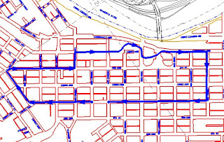
Tour Map


If you look closely at this map of the downtown area of Mankato, one of the first things that you will notice is that the "original" plat of the city was laid out essentially at right angles to the point on the Minnesota River where it bends away to the North. 
  At the time of the original founding of the city and the plan for the plat, the river was the primary access to this remote frontier location.  Therefore the plat was designed to fit into the river valley, which was essentially constrained by the bluffs, the river, the slough (where Mankato West High School and the new site of Cub's Supermarket is today) and the area known as "The Prairie".  "The Prairie" was located just north of Madison Avenue along today's Riverfront Drive.  However, because this section of land was underlain with thick layers of limestone immediately below the surface, it was considered a barrier to development.
Directions from the MSU Campus:
Follow Val Illm Drive into warren Street. Where Warren turns into a one-way street, bear slightly to the right (not a hard right). At the stop sign, turn left onto Cherry Street, (the Blue Earth Historical Society is the building on the left corner), at the next street (Fourth Street), turn right. Go halfway down the block to Jackson Street. You can park on either side of the street without a permit in this area.
Now follow the map found in the walking tour booklet.

Mankato Walking Tour by Dr. Janet Cherrington-Cucore (Dr. J)


Most college campuses have been designed to alienate students from a nearby town, rather than to connect them to it.  Because colleges and universities are self-contained communities, they often virtually stifle the need for students to learn more about the cultural, historical, and, yes, even the "funky" places that comprise a bordering community. 
 
          In my Introduction to the City course, I rally students to venture beyond the campus and into the city of Mankato.  A requirement of the course is taking a two-hour walking tour of various parts of downtown Mankato.  An interactive learning tool, the walking tour is designed to teach students several things.  First, it serves as an orientation to help first-year students learn how to navigate their way around the town.  Second, it tells students how Minnesota State University, Mankato evolved from the valley campus of Mankato Normal School (1866) to Mankato State Teachers College (1921) to Mankato State College (1957) to Mankato State University (1975) and its present highland campus location.  Third, it demonstrates to students that Mankato is a unique city with many examples of adaptive reuse, especially those done by the local government, many different styles of houses, ranging from different time periods, and many cultural and historical landmarks, particularly those that evoke a personal mental image of the city.
 
          By leading students through what was once the downtown commercial core, the tour engages students to think critically about the processes of decentralization and urban renewal and how they relate to Mankato.  It also invites students to see if Mankato has the inherent characteristics that make what author Mark Cramer[1] calls a "funky" town.  Funky means unconventional, bizarre, eclectic, or simply alternative.  An Urban Quality Indicator[2] reading assignment provides students with Cramer's 12 categories and their criteria together with a point value for rating "funkiness."  These range from peculiar local identity distinguishing one place from another to different kinds of people interacting in genuine ways to "3rd places" (beyond the campus, work or home) for hanging out that are not standard tourist spots. 
 
          After taking the walking tour, the students write a personal assessment paper and make a group presentation to the class.  Their group is the set of students with whom they take the walking tour.  Students are asked to incorporate visual technology into their class presentations, which have turned out to be no less than "awesome."  Walking tour presentations have ranged from using slides and PowerPoint to actual video productions.  More importantly, the students say they actually find the walking tour fun and many report having a changed perspective on the city of Mankato.
 
          I believe the walking tour has become a "win-win" scenario: students break the traditional "town and gown" isolation that so often plagues a community and a nearby university and Mankato gets an infusion to its economic base by students who frequent more of their sports and entertainment sites.  Lastly, the students develop a new sense of appreciation for the unique types of housing in the city that many rent while pursuing their education at MSU.